In Chapter 15 Notes: No easy exit from Panama – Why The Aegre wouldn’t sail west – Water storage – Deep-sea fishing – Landfall on the Marquesas
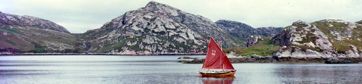
A few years after The Aegre Voyage, Julie and I were a bit surprised to find this photo on a magazine cover in a bookshop in Invercargill, New Zealand. It was taken by David Samuelson, crew aboard Jack Jensen’s Cal 46, Sartori, in Taha Uku Bay, Hiva Oa, Marquesas. See Chapter 15 for the background story.

No easy exit from Panama – Chapter 15
In Chapter 15 of The Voyage of The Aegre, I write about our difficulty getting out of the near-windless Gulf of Panama. Here are some maps that show the problem we faced(click to enlarge):


The Pacific chart above shows the principal bands of wind across the central Pacific. The great Trade Winds, the NE and SE, meet in the ITCZ (the Inter Tropical Convergence Zone), the blue band, more commonly known as the Doldrums. It’s widest in the eastern Pacific and embraces the Gulf of Panama.
This makes the Gulf an area of intermittent light winds and calms. Unfortunately, two significant ocean currents flowing into the Gulf lead to the water itself not being still. The Humbolt Current, coming up from the South, meets the Equatorial Counter Current coming in from the West. This creates a huge rotating water system between Panama and the Galapagos Islands.
The lack of wind and these currents stymies the efforts of sailors without an engine trying to reach the SE Trade Wind 1,000 miles to the southwest of Panama.
Prior to heading out we discussed the best course with other cruising sailors in Panama and studied the Pilot Chart and the Pilot Book. We had a lot to learn. Vessels with an engine and plenty of fuel may choose to motor perhaps 1,000 miles, heading out southwest past (or through) the Galapagos Islands to reach the South Easterly Tradewind, an option unavailable to us.
As I tell in Chapter 15, we chose to head south, following the coast of Columbia, to about the latitude of northern Ecuador, to gain the benefit of the southerly going current shown above, then turn south-west to sail out across the northerly going Humbolt Current, to head south of Galapagos and hopefully into the region of the SE Trade Wind. This would then take us west for thousands of miles.
If only there had been wind when we turned South-West, The Aegre would have easily stemmed the northerly going current. But the hot and windless days made progress intermittent at best. It took us three weeks in all, from Panama to reach the comforting embrace of the SE Trade wind to the south of the Galapagos.
Three weeks, much of it near stationary in water teeming with nutrients and micro-organisms brought up from the deep south by the Humbolt, now mixing with the warm water of the Equatorial Current. I wrote at the time that it was as if we were becalmed in minestrone soup. It was ideal growing conditions, and barnacles appeared and rapidly grew on The Aegre’s underwater hull despite the new anti-fouling paint applied in Grenada.
Finally, to the south of the Galapagos, a breeze settled in from the southeast, the Tradewind that we hoped would take us thousands of miles out west to the Marquesas in the central South Pacific.
But then we found The Aegre wouldn’t sail West, only North or South – Chapter 15.
In Chapter 15 I write about this disturbing discovery. We still had 3,000 miles to sail to the Marquesas, broadly west of us. Hawaii was 4,000 miles to the north, and to the south was Antarctica. In the Chapter I write about this major problem we faced and how we diagnosed the cause and fixed it. However, publishing constraints and tight editing led to much of the detail being cut. So, for those interested, here is my more detailed analysis of the issue. If the technicalities don’t interest you, you might want to skip this part.
Why wouldn’t The Aegre sail off the wind three weeks after leaving Panama? As studious sailors know, on a displacement sailing boat, two forces interact to naturally turn the boat in one direction or another. The first is the centre of effort (CE) of the combined sails, an imaginary point in the sail plan from which all the drive could be imagined coming from. The second is the centre of lateral resistance (CLR), an imaginary point along the hull which if pressed would see the hull moving squarely sideways.
Sailing boats and their sails are commonly designed so that the centre of effort (CE) is just aft of the centre of lateral resistance (CLR). This means that if left to itself, the vessel will turn up into the wind, so the pressure on the sails becomes the same on each side, the boat will then sit upright and stop. It’s safer that way, but there is another reason too.
With this arrangement, to sail in a straight line the rudder must be held so that it continually tries to turn the boat a little away from the wind. The boat then sails straight. At the same time a low-pressure area is created in the water on the windward side of the hull, (like above a plane’s wing) drawing the boat up to windward. This is a good thing as it reduced the amount of leeway the boat makes (the sideways movement away from the wind).

However, if the CE were to lie too far behind the CLR, the boat would not only want to turn up into the wind continually but it may not be possible to apply enough rudder to turn the boat away from (off) the wind, to run before it. Furthermore, the need for lots of rudder angle to keep the boat straight slows the boat down and is exhausting for the helmsman.
Conversely, if the CE were in front of the CLR, the boat would want to turn away, ‘off’ the wind continually. Apart from being dangerous for the boat as it is turned progressively further off the wind, to correct it (pushing the tiller to leeward) creates a low-pressure area on the leeward side of the rudder, leading to greater leeway of the vessel. Definitely undesireable.
So the relative positions of the CE and CLR are important and ideally the CE should trail the CLR by a small amount.
This had been the situation aboard The Aegre since we had bought her, as evidenced by the small amount of ‘weather helm’ she carried when hard on the wind. The simple wind vane self steering system had easily been able to keep her on a steady course.
But now even when the tiller was hard to windward, The Aegre wouldn’t turn off the wind. We hadn’t changed the sails so the CE couldn’t have moved (back. Therefore, I deduced, the CLR must have moved. Previously it had been a little forward of the CE, now it must have moved much further forward.
Was this because the bow of the heavily laden boat was now deeper in the water? Could the barnacles be having an effect as well? We brainstormed all the possible causes of our difficulty of steering west ie off the wind, mainly wondering why the CLR had moved forward enough to unbalance the boat’s steering:
- Too much heavy tinned food up forward?
- Weight of dinghy and anchors up forward?
- Undetected leak and water not running aft to the pump?
- Something undetected on the hull slowing us down and creating resistance?
- The growth of the barnacles?
- Rudder damage?
Donning a facemask, I went over the side to examine the hull and rudder. There were no fishing nets or big pieces of polythene snagged on the rudder, everything looked fine, but the long goose-necked barnacles were certainly long and healthy.
It had to be that the Centre of Lateral Resistance (CLR), had moved well forward of the Centre of Effort (CE) due to more of our freshwater and heavy stores being forward of the mast and pushing the forward part of the boat deeper in the water. The growth of the long goose-necked barnacles on the hull was perhaps exaggerating this effect. This could be causing the boat to turn up into the wind and making it very difficult to turn away from the wind.
Moving the CE and CLR – Chapter 15
To fix it we could do two things. Firstly, try to move the centre of lateral resistance towards the stern, and secondly try to move the centre of effort (in the combination of the sails) towards the bow.
We firstly did this by moving as much weight aft as possible to lift the bow. This included jerricans of freshwater, tinned food, the anchor, anchor chain, bags of rice, everything that was heavy. This had the effect of moving the CLR aft. This helped, but by itself was not enough.
We then tried to move the Centre of Effort in the sails forward. We did this by setting a second foresail, a flying jib that we had, in front of the existing jib, on a 3ft long makeshift bowsprit.
The combination of moving the CLR towards the stern and the CE forward helped the boat regain some steering balance under sail, and once more, we could turn The Aegre off the wind and sail west. However, the self-steering system still struggled to keep The Aegre on a steady course off the wind. We gradually accepted that it needed constant help, so frequent steering came back to be part of the Watch Keeper’s duty. An exhausting addition for the next four weeks.
Carrying enough water for this long passage – Chapter 15
In The Voyage of The Aegre book I write about our calculations regarding water. Based on our research we decided to allow one litre of water per day per person (all consumed). Initially anticipating our longest passage (across the Atlantic) might be 50 days, we decided to carry fresh water for double that ie 100 days, 200 litres.. In fact, we carried 22 x 10-litre 220 litres in 10 litre jerrycans.
The storage of our fresh water in multiple 10-litre polythene jerricans had unexpected benefits and downsides.
Firstly, any damage to a container resulting in leakage or contamination of the water wouldn’t lead to the loss of all our water but would be limited to an individual container.
Secondly, our daily water usage could be directly monitored, and our remaining water easily measured. We kept one jerrican in the cockpit, and each day, we decanted (with a siphon) our daily allowance.
Thirdly, the jerricans were made of thick polythene, and the level of the water could be seen. However, this also allowed light into the water, encouraging algae. Most of the tanks were stowed out of the light, but the one in the cockpit grew algae.
Fourthly, later in the voyage, we also discovered a further use for these water jerricans. Emptied, they became critical buoyancy.
A benefit and downside was that we could easily top up our water tanks by taking a few ashore at a time in our dinghy, without having to go along side a wharf with a water tap.
What about fishing on this long passsage?
The Aegre was a registered fishing boat in Lerwick, Shetland, LK92. I liked to think we were ‘on an exploratory voyage, looking for new fishing grounds’- a view unfortunately not shared by the Fishing Boat Registration official in Lerwick, who declined to renew our registration when we applied from Tahiti, potentially making our life considerably more difficult. I guess there aren’t a lot of Shetland boats fishing in the Pacific.
We did actually do a lot of fishing, and I’m happy to report that in 1973/4, we found and caught abundant fish in both the mid-Atlantic and Pacific. However, lacking freezer stowage (an obvious oversight on a fishing boat), we limited our catch to domestic consumption.
From the time we reached the NE Trade Wind in the Atlantic and now the SE Trade Wind in the Pacific, we were almost always surrounded by fish. This was possibly due to the barnacles growing on the hull and our generally undemanding speed. We were as if an entire ecosystem meandering across the ocean.
Some times as we sailed in the tropical waters of the NE and SE Trade Winds, it was as if the whole surface of the sea ahead of The Aegre, took off to become a shimmering low cloud of pale blue or pink flying fish, desperately trying to escape the voracious dorado fish (also known as Mahi Mahi) hard on their tail.

A few would misjudge things and fly into our sails, slithering down onto the deck, flapping noisily for a short while.
Occasionally, they flew into the cockpit at night, startling the person on watch as they noisily flapped around in the darkness. At dawn, I’d tour the deck, which didn’t take long, collecting the night’s catch. The biggest, maybe 18cm long, were destined for the pan and breakfast, the others for bait.
These shoals of Flying Fish preceded The Aegre for thousands of miles. Making the most of them were multiple families of dorado that would swim alongside The Aegre, just beneath the surface. They seemed to periodically dash ahead, eat their fill, then fall back into position close in beside The Aegre, streaking along when we were making good speed or seemingly happy to kill time swimming leisurely around us when we were becalmed.

At night, the dorado came in close, visible by the bright white trail of phosphorescence in their wake. As our deck was only inches above the water, and they were only inches below, they were alluringly close. It looked easy to spear them, but it wasn’t, and when I eventually started to get my eye in and snag one, they could be challenging to land. They were bigger and heavier than expected. I learnt to only aim for small ones.
Still, the two big white meat fillets I would slice off would be more than we could eat in a day. Julie thought they were tasteless, but I liked the freshness. Alive, they were beautiful multi-coloured fish, but would slowly fade to a plain silvery grey as they died on the cockpit floor. Watching them every day, I recognised individual fish, the big, powerful males and the slimmer, finer females.
They were not just a family; they became part of our family. Increasingly, I felt guilty about catching and eating them, so I switched to catching the more anonymous Skipjack tuna that followed in our wake, once I learned how.

We’d see the Skipjack, hundreds, maybe thousands, their dark purple-blue backs, white sides and silver bellies filling the whole face of a swell rolling up astern of us. Like underwater body surfers, there would be rows and rows of them surfing down the front of the swell. I tried every lure we had on board, but they ignored them all. Then, one day, I tried a piece of flying fish on the end of the line. It barely hit the water before there was a second big splash beside it, the line snapped taut, then broke at the nylon trace joining it to the hook.
Dammit!, My hook!
I tried again with a heavier trace but lost a second hook.
This called for a more serious approach. Using thick 10 mm rubber shock cord, I made a 2-metre loop around the mast and attached to a block. Then fed the fishing line through the block and back to a cleat on the stern. To the end of the line was attached a fine steel wire trace and baited hook. Then threw the line and baited hook far astern so the dorado wouldn’t see it.
Bang, it was instantly taken! I saw the line cutting through the water out to port. The shock cord ‘spring’ stretched to perhaps double its length. The line was so tight it was vibrating. Now, the line was stretched out hard on the port beam, and still, the fish was pulling. Pulling so hard, it was upsetting the balance of our sails and self-steering. The Aegre was being pulled off course. We were going to gybe! Chaos! Help! Help!
I eventually restored order. The fish was soon as exhausted as I was, and I could slowly pull it closer hand over hand, then bring it aboard. Later, I learnt that Skipjack tuna can grow to about a metre and up to 19kg. Luckily, this first one wasn’t that big, but its body was solid and muscular—more than enough for two days.
The catching method proved very reliable. I’d put the line-baited hook out 15 minutes before waking Julie for breakfast. This gave me time to land the fish, kill it, remove the hook, cut a huge fillet off each side, and then toss the carcass back overboard (sometimes to a waiting shark. Did I mention a shark was often stationed just aft of the rudder?).

Landfall on Hiva Oa Island, Marquesas – Chapter 15.

Described in Chapter 15, our landfall on Hiva Oa was one of our most notable, 4,200 miles and 65 days out from Panama. The island is small, and had no lighthouse or RDF station, so we had to rely totally on our Astro navigation. A supreme test of our new Accutron chronometer, particularly as we wanted to be close at dawn to be sure of making it into the one safe anchorage in Taha Uka Bay by nightfall. The chart (a scan of the chart we used from Alex Bell in Grenada) shows our course on that day, 14 June 1974, as we sailed in, close to the southern coast of this small, remote island.
Here’s a closer view of the approach to the best anchorage on the island. You can see the pencil line of the bearing I took on the intercept of Tahuata Island to the south and the southern point of Traitor’s Bay, giving an accurate position line.


In 1981, a harbour wall and, later, a marina were built in Taha Uka Bay.
Today, I’m told, there are many visiting yachts. In 1974 there was just one other yacht, Marluva from Grenville, USA, sailed by Andy and Amy Burnes, and us. Around the quiet empty Bay just tranquil forest.
Back to Listing of Chapter Notes
Back to the Home page of The Voyage of The Aegre